

Tilghman Island 🇺🇸
-
Nautical Twilight begins:05:09 amSunrise:06:11 am
-
Sunset:07:55 pmNautical Twilight ends:08:57 pm
-
Moonrise:05:48 am
-
Moonset:08:10 pm
-
Moon over:12:59 pm
-
Moon under:12:41 am
-
Visibility:0%
-
 New Moon
-
Distance to earth:363,306 kmProximity:99.5 %
Moon Phases for Tilghman Island
-
excellent Day
-
minor Time:
 04:48 am -
06:48 am
04:48 am -
06:48 am
-
major Time:11:59 am - 01:59 pm
-
minor Time:
07:10 pm -
09:10 pm
-
major Time:11:41 pm - 01:41 am
Tide Clock
Tide Graph
Times
| Tide | Time | Height |
|---|---|---|
| high | 03:53 am | 2.33 ft |
| low | 11:11 am | 0.3 ft |
| high | 04:10 pm | 1.38 ft |
| low | 10:08 pm | 0.1 ft |
| Date | Major Bite Times | Minor Bite Times | Sun | Moon | Moonphase | Tide Times |
|---|---|---|---|---|---|---|
|
Sun, 27 Apr
|
11:59 am -
01:59 pm
11:41 pm -
01:41 am
|
04:48 am -
06:48 am
07:10 pm -
09:10 pm
|
R: 06:11 am S: 07:55 pm |
R: 05:48 am S: 08:10 pm |
New Moon |
high: 03:53 am
, 2.33 ft
, Coeff: 183
low: 11:11 am
, 0.3 ft
high: 04:10 pm
, 1.38 ft
, Coeff: 76
low: 10:08 pm
, 0.1 ft
|
|
Mon, 28 Apr
|
12:36 am -
02:36 am
12:57 pm -
02:57 pm
|
05:23 am -
07:23 am
08:32 pm -
10:32 pm
|
R: 06:09 am S: 07:56 pm |
R: 06:23 am S: 09:32 pm |
New Moon |
high: 04:44 am
, 2.46 ft
, Coeff: 198
low: 12:11 pm
, 0.3 ft
high: 05:01 pm
, 1.31 ft
, Coeff: 68
low: 10:52 pm
, 0.1 ft
|
|
Tue, 29 Apr
|
01:31 am -
03:31 am
01:57 pm -
03:57 pm
|
06:05 am -
08:05 am
09:50 pm -
11:50 pm
|
R: 06:08 am S: 07:57 pm |
R: 07:05 am S: 10:50 pm |
Waxing Crescent |
high: 05:35 am
, 2.49 ft
, Coeff: 201
low: 01:08 pm
, 0.33 ft
high: 05:53 pm
, 1.28 ft
, Coeff: 64
low: 11:39 pm
, 0.13 ft
|
|
Wed, 30 Apr
|
02:28 am -
04:28 am
02:59 pm -
04:59 pm
|
06:57 am -
08:57 am
11:01 pm -
01:01 am
|
R: 06:07 am S: 07:58 pm |
R: 07:57 am S: - |
Waxing Crescent |
high: 06:27 am
, 2.43 ft
, Coeff: 194
low: 02:05 pm
, 0.39 ft
high: 06:48 pm
, 1.28 ft
, Coeff: 64
|
|
Thu, 01 May
|
03:30 am -
05:30 am
04:04 pm -
06:04 pm
|
07:59 am -
09:59 am
11:01 pm -
01:01 am
|
R: 06:06 am S: 07:59 pm |
R: 08:59 am S: 12:01 am |
Waxing Crescent |
low: 12:33 am
, 0.23 ft
high: 07:21 am
, 2.33 ft
, Coeff: 183
low: 03:00 pm
, 0.46 ft
high: 07:45 pm
, 1.31 ft
, Coeff: 68
|
|
Fri, 02 May
|
04:33 am -
06:33 am
05:09 pm -
07:09 pm
|
12:00 am -
02:00 am
09:07 am -
11:07 am
|
R: 06:05 am S: 08:00 pm |
R: 10:07 am S: 01:00 am |
Waxing Crescent |
low: 01:35 am
, 0.33 ft
high: 08:18 am
, 2.13 ft
, Coeff: 161
low: 03:55 pm
, 0.52 ft
high: 08:45 pm
, 1.35 ft
, Coeff: 72
|
|
Sat, 03 May
|
05:32 am -
07:32 am
06:06 pm -
08:06 pm
|
12:47 am -
02:47 am
10:18 am -
12:18 pm
|
R: 06:03 am S: 08:01 pm |
R: 11:18 am S: 01:47 am |
First Quarter Moon |
low: 02:46 am
, 0.46 ft
high: 09:20 am
, 1.97 ft
, Coeff: 142
low: 04:49 pm
, 0.59 ft
high: 09:47 pm
, 1.41 ft
, Coeff: 79
|
")


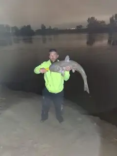
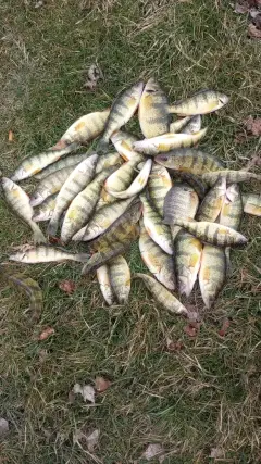
uploaded by: Mr catch it
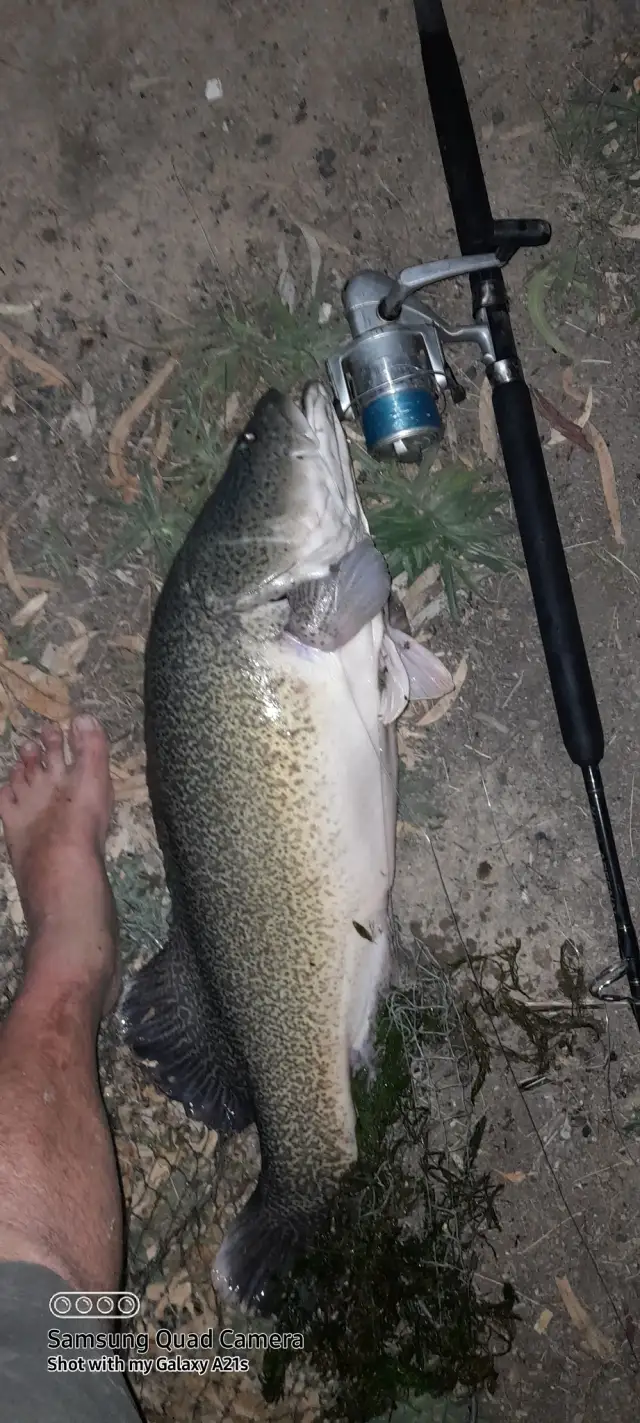
uploaded by: Graeme Lhuillier

uploaded by: Tony Barker_1

uploaded by: Zander Paul Slabber

uploaded by: Craig Aulenback

uploaded by: Craig Aulenback

uploaded by: Craig Aulenback

uploaded by: Craig Aulenback

uploaded by: Eric Dixon_1

uploaded by: Stixy
Best Fishing Spots in the greater Tilghman Island area
Wharf's or Jetties are good places to wet a line and meet other fishermen. They often produce a fresh feed of fish and are also great to catch bait fish. As they are often well lit, they also provide a good opportunity for night fishing. There are 1 wharf(s) in this area.
Lowes Wharf - 7km
Beaches and Bays are ideal places for land-based fishing. If the beach is shallow and the water is clear then twilight times are usually the best times, especially when they coincide with a major or minor fishing time. Often the points on either side of a beach are the best spots. Or if the beach is large then look for irregularities in the breaking waves, indicating sandbanks and holes. We found 2 beaches and bays in this area.
Armstrong Bay - 11km , Trippe Bay - 13km
Harbours and Marinas can often times be productive fishing spots for land based fishing as their sheltered environment attracts a wide variety of bait fish. Similar to river mouths, harbour entrances are also great places to fish as lots of fish will move in and out with the rising and falling tides. There are 1 main harbours in this area.
Poplar Harbor - 7km
We found a total of 99 potential fishing spots nearby Tilghman Island. Below you can find them organized on a map. Points, Headlands, Reefs, Islands, Channels, etc can all be productive fishing spots. As these are user submitted spots, there might be some errors in the exact location. You also need to cross check local fishing regulations. Some of the spots might be in or around marine reserves or other locations that cannot be fished. If you click on a location marker it will bring up some details and a quick link to google search, satellite maps and fishing times. Tip: Click/Tap on a new area to load more fishing spots.
Avalon Island - 1km , Dogwood Harbor - 1km , Tilghman Island - 1km , Pawpaw Cove - 1km , Bar Neck - 2km , Upper Bar Neck Point - 2km , Boat Point Cove - 2km , Amys Marsh Point - 3km , Blackwalnut Cove - 3km , Lower Bar Neck Point - 3km , Muddy Cove - 4km , Bald Eagle Point - 4km , Blackwalnut Point - 4km , Turkey Neck Point - 4km , River Cove - 4km , Change Point - 4km , Dun Cove - 5km , Middle Point - 5km , Seth Point - 5km , Goat Island - 5km , Long Point - 5km , Great Marsh Point - 5km , Green Marsh Point - 5km , Johns Cove - 6km , South Bar Point - 6km , Balls Creek - 6km , Indian Point - 6km , Locust Neck - 6km , Nelson Point - 6km , Long Cove - 6km , Coaches Island - 6km , Old Orchard Point - 6km , Cabin Cove - 6km , Punch Point - 6km , Steves Cove - 7km , Fishing Point - 7km , Judys Point - 7km , Ferry Cove - 7km , Smith Point - 7km , Waterhole Cove - 7km , Blades Point - 7km , Cooper Point - 7km , Bromwell Cove - 7km , Cherry Tree Point - 7km , Poplar Harbor - 7km , Lowes Wharf - 7km , Piney Point - 7km , Caulk Point - 7km , Harbor Cove - 8km , Fairbanks Point - 8km , Valliant Point - 8km , Meetinghouse Point - 8km , Wells Point - 8km , Lowes Point - 8km , Boby Owl Cove - 8km , Jefferson Island - 8km , Big Point - 8km , Little Neck Point - 8km , Caulk Cove - 8km , Briary Cove - 8km , Poplar Island - 8km , Bridge Creek - 9km , Skinners Point - 9km , Royston Island - 9km , Cook Point - 9km , Grace Creek - 9km , North Point - 9km , Deep Neck Point - 9km , Rabbit Point - 10km , Point O' Pines - 10km , Holland Point - 10km , Lucy Point - 10km , Edgar Cove - 10km , Cummings Creek - 10km , Sharps Island (historical) - 10km , Mulberry Point - 10km , Cedar Point - 10km , Haskins Cove - 11km , Armstrong Bay - 11km , Elberts Cove - 11km , Edwards Point - 11km , Irish Creek - 11km , Hambleton Island - 11km , Deep Neck - 11km , Church Neck Point - 11km , Fox Hole Creek - 12km , Hopkins Point - 12km , Drum Point - 12km , Ferry Neck - 12km , Barrett Cove - 12km , Edge Creek - 12km , San Domingo Creek - 12km , Cook Point Cove - 12km , Todds Point - 13km , Trippe Bay - 13km , Solitude Creek - 13km , Benoni Point - 13km , Covey Creek - 13km , Maiden Point - 14km
Comments